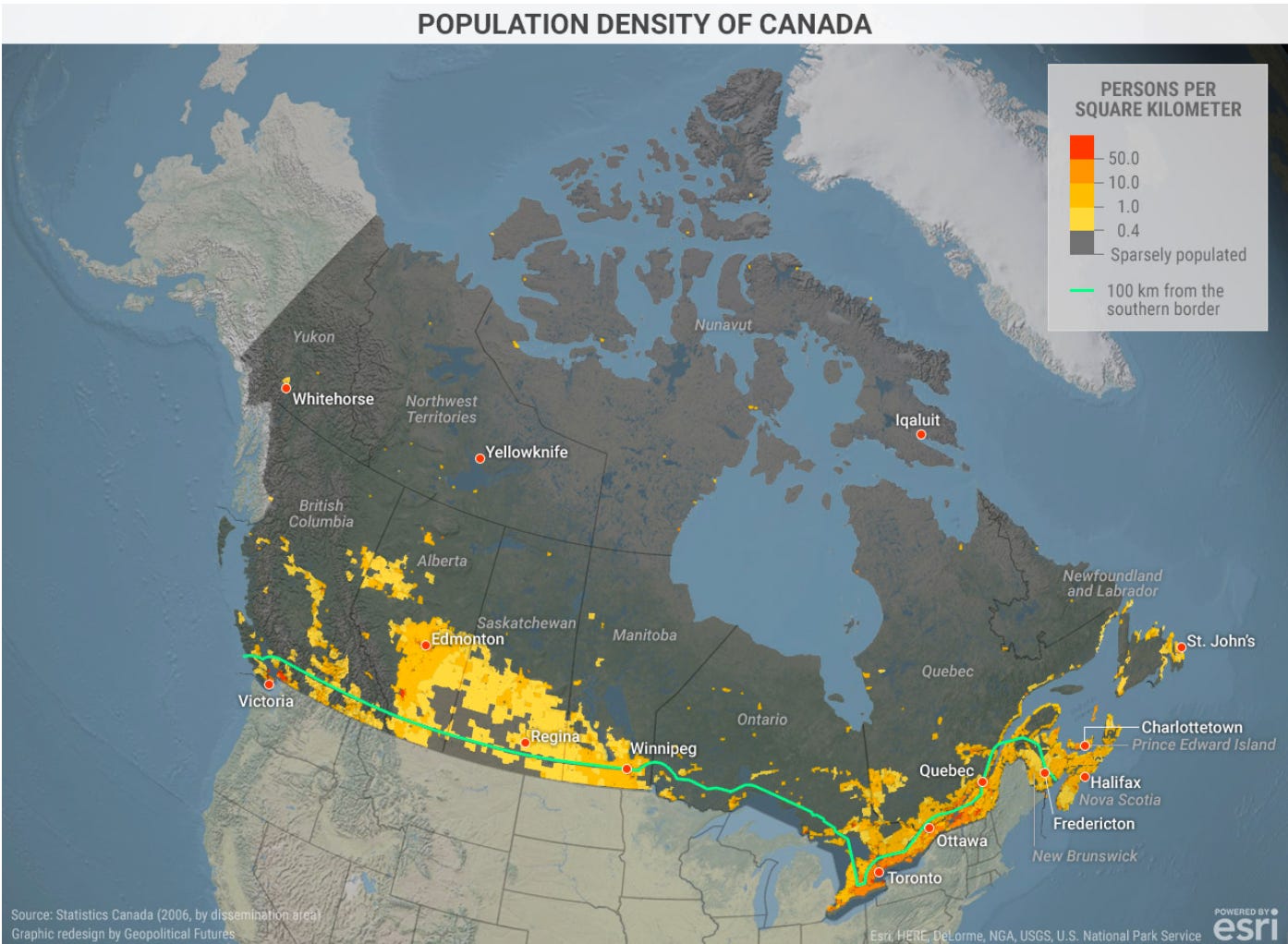
ONE IMAGE: 40 Million Canadians
The country that, as an American, I so often find falling into the Uncanny Valley...
The country that, as an American, I so often find falling into the Uncanny Valley...
<https://geopoliticalfutures.com/population-density-of-canada/>
I do not know about you, but I would consider anything less than 10 people per square kilometer—25 people per square mile—“sparsely populated”.
Figure that is five farming families per square mile. That means 130-acre farms, a little less than the U.S. 1862 Homestead Act allotted, which I had always thought was geared to the low-water environment of the trans-Missouri and hence to a sparse population.
Where the people are:
Greater Toronto: 6 million
Greater Montréal: 4 million
Greater Vancouver: 2.5 million
Greater Ottawa-Gatineau: 1.5 million
Greater Calgary: 1.5 million
Greater Edmonton: 1.4 million
That’s 17 million people—42% of the population—living in metropolitan areas of one million or more, my benchmark for people whose life experience is truly “urban” by the standards of the 2000s. Compare to 47% for the United States and Germany, 43% for Mexico, 40% for South Africa, 31% for China, and 17% for India and Nigeria.
What other things should one know about Canadian geography?
90% of the Canadian population live within 100 miles of the U.S. border (with about 20% of Canadian production exported to the United States, and 15% of Canadian consumption and investment purchases imported from the United States).
Canadian GDP per capita is US$55,000 per year (compare to US GDP per capita of US$82,500 per year.
Canadian life expectancy is 79 for men and 84 for women (compare to US 75 and 80).
Population density within 100 miles of the US border is about 100 people per square mile (compare to about 1 person per square mile in the rest of Canada, 40 people per square mile in the trans-Mississippi United States, and 150 people per square mile in the United States east of the Mississippi).
The median age is 41.6 years
Visible minorities constitute about 25% of the population—South Asian, Chinese, Black, First Nations (6%), and so forth.
98% can speak either English or French. The proportion who can speak both English and French goes from 50% in Québec and 34% in New Brunswick down to 10% in other provinces.
23% of Canada’s population was born abroad, with only 1% born in the US.
The current lifetime fertility rate is 1.33 children per potential mother.
If reading this gets you Value Above Replacement for the use of your time, then become a free subscriber to this newsletter. And forward it! And if your VAR from this newsletter is in the three digits or more each year, please become a paid subscriber! I am trying to make you readers—and myself—smarter. Please tell me if I succeed, or how I fail…


You might find Australia even more striking. Lower population density than Canada and heavily crowded into into a handful of coastal cities. I've read that if you take out the Great Lakes the USA and Australia have about the same surface area. But Oz only has about 26 M. Significantly less than even California.
'I do not know about you, but I would consider anything less than 10 people per square kilometer—25 people per square mile—“sparsely populated”'
I don't know that 'sparsely populated' has a specific meaning, but I suspect that the meaning in this particular case is that one cannot meaningfully measure 'persons per square kilometer'. My understanding (possibly mistaken) is that there are large areas of the far north that have effectively zero permanent population.